Saturday, September 08, 2007

Longs Peak


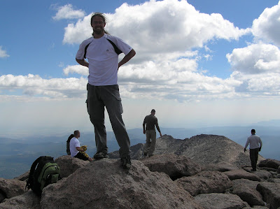
It had been about 3 weeks since I arrived in Colorado and I had not yet climbed a fourteener. So on Satuday I got up at 4:30 and drove to Longs peak. I went up the Loft route which is the less traveled of the 2 non-technical routes on the peak. The route leads right up between two massive cliffs. When starting up the valley it looks as if the route runs right into a wall. But as you get closer up there is always a ledge that lets you angle up to a higher point. I got stuck once when I walked to the left along a narrow ledge and it came to an end. But from this vantage I could see clearly the place I should have switched back about 15 ft straight below me. It took only a few extra minutes to go back across the ledge to where I could get down and back on track. Near the top the route I was on joins the Keyhole route, the standard way to get up the mountain, the last pitch is called the Home stretch, It is not as steep as the cables on Halfdome, but just as busy, there are a couple of wide cracks angling across a broad slope of granite. It is not that difficult to go up, if you trust your balance, but many people don't and you can see them crawling or sliding along on their butts. On top there were dozens of people. I asked to get my picture taken and ended up talking for a while with a group from Colorado Springs.
On the way down I went through the Keyhole. Long's peak is pretty spectacular from both sides. Although the view from the downward half of the climb that sticks with me is when I was standing in the Keyhole notch and seeing the lines of hikers stretched out across the boulder field below.

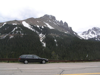
Photos: First- The summit shot, as you can see it was not lonely at the top. Second- the keyhole that give the keyhole route it's name, again there was no way to get a picture with out capturing the bystanders, on the other hand he adds a sense of scale to the picture.

Saturday, September 01, 2007

My apartment


I moved into the Edgewood Apartments in Westminster, a western suburb of Denver. I got my couch, bed, bike, and coffee table at the flea market, I got the desk and chair at the thrift store.

Wednesday, August 15, 2007

Moving to Colorado

I loaded my possesions into my car, which didn't take long because most of them were already in there, and headed to Colorado. I stopped at rest areas a couple of times to catch a nap. It was getting late as I approached Denver so I got off the highway and found a dirt road heading into a national forest and pulled over, put the seats down to get a good nights sleep. I bathed in a small stream at first light and headed into my new home town with an ambitious list of things to get done on day 1. I spent most of the day driving around looking for some place to get on line, and every little thing took along time because I had to figure out where I was and where I was going and usually had to stop along the way to figure out where I was and where I was going. The first night I headed out of town looking for camping. I had to go quite aways to get away from the private homes that extend up into the front range. After that I took advantage of the hospitality of Aunt Joyce and Uncle Daryll for about two weeks while I got started with classes and searched out an appartment.
Photo: Trucks at rest stop in Idaho

Saturday, August 11, 2007

Passing through Washington


At the end of every contract I have to pass through Seattle to make sure that all of the data I collected is in the proper format and was obtained using valid methods. I took good advantage of the time in the Northwest. I got in some camping on Mt Hood with Dad, Uncle Bob and Andrea; a family reunion; and some rock climbing and river riding with Juliette.
Photos: First- Gearing up for a predawn hike on the slopes of Mt Hood. Second- Juliette at the Gunshow area off Exit 38 of I-90.

Sunday, July 29, 2007

Hickory Wind


After 3 weeks of easy shifts at the plant in Dutch Harbor. Saltwater Inc. flew me into Kodiak for a quick trip on the Hickory wind. They told me it would be for a day, but that sounded suspicious. I was aboard for 2 days, still the shortest trip I have been on.

Picture: Sablefish (or Black Cod) are a high dollar fish. At the time it was selling for about 5 bucks a pound. And each one weighs about 4 to 5 pounds. The orange fish are Short Spined Thornyheads (or Idiot fish). Despite the name the spines are long enough to poke through gloves. This one was probalby forced in the the mouth of the sable fish when they were mashed together in the net.

Wednesday, July 11, 2007

Hiking in Dutch


working at the Plant in Dutch Harbor is wonderful, mostly because of the hiking opprotunities. I managed to get out a few times to enjoy the summer weather and the tundra around the town.
Pictures: Taken from the valley south of Captains bay, on the way to an unnamed peak, point 2699 ft on the USGS map.

Wednesday, July 04, 2007

4th of July


I got assigned to a plant for a few weeks so I was around Dutch Harbor for the fourth of July. The fireworks started at 11:59 PM on the 4th; it was almost dark. The low clouds absorbed most of the fireworks but there were a few low ones that we got to see. The Russian Orthodox church is in the forground of the picture.

Thursday, June 28, 2007

Back To Alaska

After about 2 months on the road I arrived back in Western Washington. I stopped in Bellingham long enough to wash my car and make a couple of border runs to get Juliette's work visa renewed. Then we headed to Seattle and briefed for another trip to Alaska.

Sunday, June 24, 2007

Climbing in Bozeman


Pictures: First - Juliette climbing, with some guy hanging out in the background. Second - Karen and I up by the college "M". Karen was kind enough to tollerate a couple of guests for a couple of nights.

Thursday, June 21, 2007

Yellowstone


It would have been nice to camp over night in Yellowstone, Juliette really wanted to get out where we would have a better chance of seeing bears and wolves. But we were a bit tired after the Rockys and the Tetons. We found a wonderful free campsite by the river just south of the park and spent a couple of days making the rounds of the common sights.
Pictures: First - This Buffalo wandered across the board walk by old faithful, right through a crowd of hundreds of people waiting for the geyser. Second - Me standing in front of Old Faithful. Third - Morning Glory pool.

Wednesday, June 20, 2007

Jackson Lake


Jackson lake is as the foot of the Tetons. We rented a canoe and canoed 12 miles up the lake to a very nice campground. There were lots of wild flowers in bloom. We gathered some fire wood and had sausages and marshmallows.
Pictures: First -- Juliette paddling hard while I sat back and took some pictures; Second: My car with a canoe on top.

Tuesday, June 19, 2007

Wyoming Tourist Trap

The Bait for this trap was several nice campsites that could clearly be seen down a dirt road. Of course the best ones were way down at the bottom. The road didn't seem too bad, it was a two track, but the tracks were fairly even with a few small rocks in them. We started down the hill and realised that it was steeper than it looked. When we got to the bottom Juliette thought we should try going up the hill to make sure we could get out again. On the first attempt I got about two thirds of the way up the hill before I started smoking the tires. I started to back down, but hung up almost immediately. I assumed it was a rock, but when Juliette got out and looked she came back with a horrified look on her face. The muffler had hung up and crumpled under the tire. I could not back down because the muffler was wedged under the tire and I could not go up because the hill was too steep. I put rocks under all of the the other tires so that the car would not move while I worked on the muffler. I then jacked up that corner of the car to take the pressure off the muffler and eventually dislodged it. Then I could back down the hill and take another run. Using the Cameroonian theory that the solution to all automotive hang ups is to "put more fire" I floored it and the car went bouncing up the hill.
Pictures: First- dislodging the muffler (Tip for the photographer: next time rotate the camera a little to the right, not only would this make the hill look steeper, it would keep the trees pointing straight up) Second - Juliette, happy to be in her new tent, at the first campsite nearest the main road.

Saturday, June 16, 2007

Rocky Mountains

Pictures: First - Juliette and I enjoying the view and eachother's company near the top of Sprague peak.

Second - Signing the register at the top of Sprague peak. We didn't realize that we were climbing a mountain. Juliette suggested going up the side of the valley because the trail we were following along the bottom was covered with snow. So we went up. Each time we thought we were to the top of the hill we could see that there was another top just a little farther on. Finally after many false summits we found a point where ther was no more up to go, and sitting there was a cannister with pen and paper, where we found the name of the peak and the elevation: 12,730

Third - Juliette hiking along side big meadows.

Wednesday, June 13, 2007

Introduction


This is Juliette. She is from Cape Breton, Nova Scotia. I met her in January in a 4 day training class that we are required to take every year before going to Alaska to work as Marine Fisheries Observers. She flew down to Denver and I picked her up at the airport. I thought I might introduce her here so that if you see her in pictures later on you don't have to wonder who she is.

Monday, June 11, 2007

Colorado

I wanted to drive through Colorado to check out the University of Colorado in Boulder. I had a meeting with the Graduate coordinator there and decided that it would be a good idea to go to grad school even if it meant taking some classes at Community College to be elegible for the Civil Engineering department.
I stopped by La Salle to see the Westover clan and then headed out toward Gould to camp. Passing through Cameron pass on Highway fourteen, the first thing to come into view is the square, craggy profile of Mt Richthofen.

I decided that I had lots of time and no particular reason to get to any particular place so I found a road leading off toward the mountain and parked. I wandered up some service roads and then started up a ravine until I could get up on the ridge line. I followed the ridge up to the jagged rocks of the summit started. I climbed up and down along the serrated edge of the ridge over rocks that looked solid but in some cases came loose in my hands and went rolling down the scree below. I came to a place where I would have to climb straight down about 10 ft cross about 10 ft of a tiny little saddle and then start climbing nearly straight up the last couple of hundred feet to the top. I thought I could do it but it would be dangerous with the loose rock, and I thought of a few good reasons not to risk my life that day and turned back.


Pictures: First - Mt Richthofen from the road where I decided I had to climb it; Second - The mountain from the ridge. I made it as high as the first big notch to the right of the summit, the third picture was taken in the second or third notch. Third- Looking south east (into Rocky Mt National Park) from a vantage high on Mt Richthofen.

Monday, June 04, 2007

canyonlands

Photos: First- Journal on a rock out side of Canyonlands NP. I spent an hour catching up my record of daily activities, while waiting for the sun to set. Second- Some slickrock hills near the parking lot, taken in the evening after a very long dayhike. I forgot my camera on the hike so you don't get to see pictures of the slot canyon or the Druid arch.

Third- I was trying to climb up on a rock to get a better view. A piece of sandstone broke off in my hand, exposing this tiny little bat that had been hidding in the crack.

Friday, June 01, 2007

Arches

Like all national parks, the camp sites are expensive. Fortunately I found a gravel side road that led to a more remote arch and parked along the road there for the night. In the morning I followed the road to the end and found Tower Arch. and spent some time exploring the cracks and canyons behind the arch and around the tower. In the afternoon I went to the more visited area of the park and strolled through the Devil's garden. I snuck down the gravel road again in the evening for another night of free parking. The next day I hiked out to Delicate arch.
Photos: First - Shadow of double arch. Second - Delicate arch

Tuesday, May 29, 2007

Kristina Lena


When I got to Saltlake City I stayed for a few days with Christina Udy, a friend from Peace Corps. We went for a hike one day, then we went to dinner with her family. She has some boisterous siblings. One is a very commited mormon and her children wear collared shirts and have neatly combed hair, another lets his kids go to bed any time they want, he tries to give candy and soda to his nephews and nieces that are prohibited these things by their faith.
Since I was in Saltlake I thought I would be remiss if I didn't go to the Mormon Temple. According to Mormon tradition young people are expected to spend two years as missionaries. Many of the young men are sent abroad, however some conservatism keeps them from sending out their young women so freely. Women are more likely to spend their missionary years working closer to home. Some few of them get to work as guides around the temple. I think that the mormons must choose only the most attractive young women for this duty, to tempt any men who might visit the temple to convert to Mormonism. Unfortunately for them, I was visiting the temple with an attractive young woman who was not inclined to have me converted.
Picture: Kristina Lena looking up at Jesus. We sat on padded benches regarding the statue for a while. A tour group came through and the guide pressed a button promting the deep resonating voice of God to speak about the creation of the cosmos.

Friday, May 25, 2007

Driving Across Nevada


High way 6 across Nevada was not as boring as I expected it to be. Nevada has a number of mountain ranges running north and south and as I headed east across the state I got to cross them. Coming out of the moutains in California I could see the next range a head with a broad flat vally between. After driving straight across the plain I wound my way up and over the next pass. As I came over each range I could see the road stretching straight to the next range; no trees or buildings to block the view. The longest straight away was 26 miles.
I stopped at the Lunar Crater, which was about 10 miles down a gravel road. The Crater is actually volcanic in origen but seems out of place in a mostly flat landscape. It has an uncanny resemblance to the female lake mount Manangouba. Exept that there was no greenery and there was sand instead of a lake in the bottom.

Thursday, May 24, 2007

Halfdome


Climbing Half dome in Yosemite I noticed an interesting example of stratification. Not in the geological sense. Yosemite has one type of granite rock that goes all the way up. There were definite lines drawn in the types of people that I met along the trail. In the town on the valley floor there are all types of people in the giftshops and being carted around in trailers on tours, they were predominantly over weight, elderly, or handicapped.

The first part of the trail up the mountain was past some waterfalls. The population that most used this trail was families with young children, and some retired folks who wanted to go for a short hike. After getting up past the falls there is a relatively flat area through some pines. The trail connects here to some back country campsites so the people on this section of trail are likely to be carrying larger packs. Several middleaged couples and a large highschool group were coming down this part of the trail.


As the trail continues up hill from there it is the twenty to thirty age bracket that dominates. Many of them couples in trendy sports wear, the unwritten rule is that women are not allowed to carry the day pack, although most of them appear in excellent shape and quite capable.


There were lots of people at the top, but the two that every one looked up to were the ones that had the 'biners hanging off there belts with a rope slung over the shoulder. They came up the hard way.

Pictures: First - At the top, along the steep edge there is a ledge hanging over thousands of feet of empty space. Second - The last 400 feet are lined with cables to aid climbers to the top, there are as many people waiting at the bottom of the cables as there are on top of the mountain. Third - There is a pile of hundreds of old gloves at the bottom of the cables, most of them are in pretty bad shape.

Wednesday, May 23, 2007

Sequoia and Kings Canyon

Sequoia and Kings Canyon national parks border each other and the only way to get to Kings Canyon is to take a road that passes first through Sequoia.
Sequoia has lots of short trails that lead to view points or particularly large trees. There are lots of people roaming around. One trail I took led me into an immense campground where it came to a cross walk and left me standing with no where to turn except cutting across campsites or following the paved roads. The largest trees are surrounded by fences and loops of interpretive trails, although even the smaller sequoias are immense compared to any other tree.
After driving along a road next to a raging river through the narrow Kings Canyon I arrived at the Road’s End trail head. Looking at the map I randomly selected one of the trails and headed up to Paradise valley. On either side of the valley are massive granite cliffs. The trail to Paradise valley climbs up past a waterfall to a friendly valley with three campgrounds stretched along it. As the trail crosses the rocky area near the waterfall I met a couple coming down the trail. They said that there was a rattle snake up ahead. I kept my eyes open and, as the trail got steep and went up some rough stairs of granite blocks, I saw the snake, right under the corner of one of the stairs. Farther up as I passed a gap in some rocks at the side of the trail I heard a rattle, I took a step back and as I crossed in front of the gap again the rattle repeated. After I peered among the rocks I spotted the second rattler. Then on the way down there was one more stretched full length on the trail. He posed just long enough for a picture and then slid off to one side.
It is acceptable to park/camp along the road in a National Forest but not in the National park. So I drove about a couple of miles out side the park boundary and pulled off in a turn out near the river.
In the morning I got up and drove back to Road’s End. This time I headed up to Avalanche Pass and a spot on the map called The Sphinx. Shortly after I started hiking I saw a bit of movement to the left of the trail, as I approached I heard something moving up the hill. When I got up to the point where I saw the movement I looked up through the trees and saw a brown black bear. He was completely unconcerned with me and I watched him for a while until he disappeared in the trees.
As I hiked along the valley floor I looked up at the cliff faces and sitting on top of one was a pile of rocks that looked vaguely like the Sphinx he even had a small pyramid next to him. I took the right fork in the trail and started up a long series of switchbacks. Sphinx Creek was always near by, but took the more direct route; tumbling straight down the ravine. The trail climbed out of the trees and gave some very impressive views of the valley as it crossed and recrossed a rocky area. Eventually I arrived in a fragrant valley full of pines. The trail crossed the stream and then started switch backs up the other side of the valley. After the trail turned back on itself one last time it went almost straight for a mile across to Avalanche Pass. The wind has swept the ground bare around the wonderfully wind swept old trees in the pass.
On the way down I stopped at the first switch back and headed up and over the ridge to sneak up on the Sphinx from behind. From a rocky outcropping on the end of the ridge I spied him down the other side. I followed a narrow ridge down through the trees and scrambled up the bare rock of the pyramid. From there I could look about 4000 ft down to the valley floor. The Sphinx itself was well protected by a gap that I dared not attempt.
Arriving back at the parking lot the bear was in the trees near my car. He was tearing up the bark on dead trees looking for grubs.

Saturday, May 19, 2007

Visalia

I stopped in Visalia to see my cousin Mark. In the afternoon we took a look at his orange orchard. There were a few remaining oranges hanging on the trees that were killed by the frost in January, but the blossoms and developing fruits looked promising. We also stopped at a dairy farming operation. The cows come into the milking barn and take one of 80 spots on a giant carousel. As they are slowly turned over the next few minutes, one man cleans the teats, the next attaches the milkers. After the a few minutes the milkers are removed and the cows back out near the point where they started. The cows apparently enjoy the ride so much that the bull will some times come in and go for a ride himself.

Thursday, May 17, 2007

La Brea


On my way out of the LA area I stopped at the La Brea tar pits. I was a bit concerned when there were a dozen school busses parked along the road, but I came in while most of them were finishing up. I didn’t realize the sheer number of bones that they had found. They have a wall in the museum with 400+ skulls from dire wolves. Some other species are less numerous but there are still hundreds of individuals found in the tar. There were some interesting skeletons and models in the museum, and a nice park with some bubbling tar pits.

Wednesday, May 16, 2007

Uncle Bob

I left Ventura and drove to Ontario, where I stayed a couple of nights with Uncle Bob. While he was teaching school I washed and vacuumed out my car. Then we made a short day hike up Icehouse Canyon after he got done with school.

Monday, May 14, 2007

Santa Rosa

I reached Ventura and met Lisa at her house. We went shopping to find food for the week and packed up.
Tuesday morning we headed out to the dock to board the boat to Santa Rosa.
It was about a 3 hour ride out to the 3rd island in the Channel Island chain. On the boat I met Anna, a botanist and Betsy who is working with the St Louis Zoo collecting information about the captive breeding of the island foxes. When we arrived the departing staff left the vehicles on the dock, a truck with a crane moved the baggage from the boat to a truck and we drove up to the park service housing. There is a small suburb on the side of a hill where the park staff stay. It was really quite nice. Lisa showed me to the room of a vacationing co-worker; it had a queen sized bed and a bathroom attached. Then we took a ride down to the dirt landing strip where the plane was coming in. Trish got off the plane, she had finsished some fox research on San Miguel island and decided to stay on a week to check things out on Santa rosa.
Over the next week I got to see most of the different areas on the Island. Lisa was busy locating the island foxes using radio tellemetry, so she couldn't go hiking with me, but when she had to drive to the far flung corners of the island she could drop me off (and Trish and Betsy who were less busy) and we would only have to hike back, making it possible to see things that we wouldn't have been able to get around to otherways.
The grove of Torrey Pines that grow on the island is one of only 3 in the world. They don't grow very tall but some of the gnarled trunks are pretty thick. The dry air blowing over the pines is very fragrant.
Down at the beaches on the south side of the Island there are wonderful sandy beaches that are occupied and odorized by dozens of elephant seals. The elephant seals are very lazy and indifferent to people walking by. We also saw some harbor seals laying on the rocks off shore, but they are much more wary of humans and floundered into the water when we came around the corner.
At a place called China Camp there is an Chumash graveyard and mizzen. As the beach erodes away bones and other objects are uncovered. there were many bones that were not human, and the Chumash affinity for red abolone was apparent by all of the pearly shell fragments. I found some ribs and a couple of Skulls that were exposed. The crania were intact but the jaws and facial structure below the eyes had eroded away.
Lobo Canyon is the most spectacular of the many canyons that radiate from the center of the island. It is not grand in scale but the sandstone has erroded in some unique shelf like formations.
I made along day hike out to Carrington point on the north west of the island. the rocky cliffs along the shore here make for good seabird nesting. There are several natural arches that have formed along the surf line.
There was plenty of variety to keep me busy on the island and I think I went at the right time of the year. Lisa said that the weather had just turned nice, in the winter it tends to be foggy and cold; and there were a myriad of tiny wild flowers blooming all over the island.
Tuesday rolled around again and the boat came and those of us on the island left while the other shift came on.


Pictures: 1) Betsy and Trish hiking in Lobo Canyon. 2) A natural bridge over a small inlet near Carrington Point, and me running to beat the auto timer. 3) Standing on the beach with the elephant seals. The large males with their namesake snouts had left the beach earlier in the year, these are the molting juveniles who are sticking around. 4) Dirk and Anna making a botanical transect. They measure off a line 30 m long and identify the plants at 30 cm intervals; giving 100 points of data that can be compared to the species present along the same line from year to year. Now that the ranch has stopped raising cattle the plant diversity is slowly reverting to its prior state. Many plants need two or more good years in a row to establish themselves and get their roots deep enough to survive a drought year. The right combination of good years might not come around more than once in 10 0r 20 years it will be along time before the island returns to its previous state.

Monday, May 07, 2007

Pinnacles


As I was driving down the 101 I was hungry and I saw a brown sign that indicated there was a park off the next exit. I thought that it would be nice to eat lunch there so I got of the freeway. I had to drive up a windy little road but eventually came to Pinnacles National Monument. I took a hike around a loop and saw some California Condors along the way. The trail led through a talus cave, which is formed when large chunks of rock fall and block up the top of a narrow canyon, leaving empty space at the bottom.
Picture: I Played around with the auto timer near the entrance to the cave.

Saturday, May 05, 2007

Cinco de Mayo

I showed up in San Francisco on May 5. After Coming across the Golden Gate bridge I followed the directions Monica had given me through town and over the hill. The cross streets on the steepest hills have stop signs, which means I had plenty of opprotunities to test my skills with the stick shift.

I found Monica standing on a street corner and she quickly hopped into the front seat with all of the junk that should have been in the back but had migrated forward after I used it. She took me around several blocks looking for parking. We found a spot and fortunately it was the weekend so I could just leave my car there.

We started the party with margaritas at Monica's appartment. We had to mix them strong because the store was out of margarita mix. We headed out to the bar and I got to see Susan for a little while. The Corronas came with festive little ponchos draped over their necks.

The 6th Monica and I hung out at the park with her Cousin, went on a cable car ride and went shopping at Macy's. We cooked some fish and vegetables and made a nice dinner.
Picture: Waiting for the trolly. The guy operating it had to pull levers that moved huge gears to change the car from one under ground cable to the next.

Redwoods

I drove down I-5 in Oregon and branched on highway 199 to California. 199 is very nice winding among giant trees and then coming out along the coast with views of the ocean. At Crescent city I turned on 101 which continues through the Redwoods state and national parks, however there is more of the tourist quitch along the roads and the roads were a bit busier.
I took a secenic by way down a gravel road along the coast and pulled over in a turn out. I put the seats down in the back and spread my blankets out and spent the night there.
In the morning I pulled over after seeing a sign for a trail head. I took a 3 mile loop through the trees. Three miles was a bit much, once you've seen one . . . Picture: Me in front of a pretty big tree. This one was bigger than average but not exceptional among the trees in the forest.

Friday, May 04, 2007

10 Waterfalls in 8 Miles

After a final day rock climing, I finally got out of the company appartment in Seattle. I spent a couple of days staying with Uncle Jerry and Aunt Faye in Bellingham. While I was there I got to see my sister Andrea and my cousin's family. Then I headed south.

That night I pulled into Silverfalls State Park in Oregon. It was late and there was no one at the gate so I just pulled in and parked in a camp site. For the first time I folded down the seats in the back of my car and spread out my blankets. I slept pretty well, if I lay at a slight angle I can stretch out flat with out bumping my head or feet. It rained over night but that didn't disturb me in my car.

In the morning I got up and moved to the picnic area and trail head. The most popular trail is an eight mile loop that takes one past 10 water falls. The weather was kind of grey but I put on my new shoes and carried my rain jacket along. There were 10 very nice waterfalls along the trail but the thing that really fascinated me was a dead beaver laying right in the middle of the trail. Apparently he had fallen from a cliff above the trail, but he was in good condition.

It didn't rain and I even saw the sun now and again as I walked along. The trail was like a side walk. Even though there was rain the privious night and every thing was wet my shoes came out looking like new. That was kind of dissappointing.
Pictures: 1- The tail of a dead beaver. 2- Lower north falls, seen through moss covered trees. 3- Middle North Falls, I walked the path that leads behind this fall to get this picture from the far side.